Many people dream of visiting Norway and getting unforgettable impressions of the country, its nature, and its culture. Norway is so rich in insights that when you start planning your trip, you can get confused and miss something very important.
What comes to mind when you think of Norway?
Let’s see what places you have already included in your itinerary, and what else should be added!
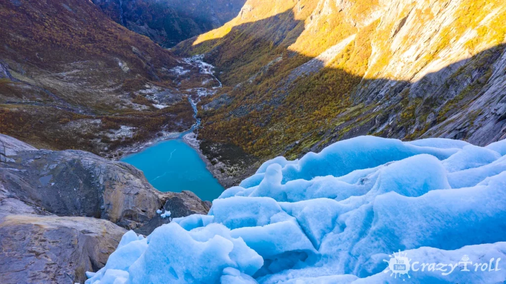
Jostedalsbreen glacier
Jostedalsbreen glacier view from the glacier arm on the valley
Norway is a rare country that still has glaciers. The largest glacier in continental Europe, Jostedalsbreen, is also located in Norway. All over the world, glaciers are rapidly melting and disappearing, which is why it is so important to have time to see them with your own eyes.
The Jostedalsbreen Glacier National Park is located in the Sogn og Fjordane region. The Jostedalsbreen glacier itself has an area of 487 square kilometers and it still has about 50 glacier arms, but only a few of them are accessible to tourists.
All glacier arms are very different, some can be seen directly from the car park, such as Bøyabreen Glacier, and some you have to walk to, such as Nigardsbreen Glacier.
So which side to visit the Jostedalsbreen glacier is up to you! And it also depends on the degree of your physical fitness and the desire to walk uphill. But it is definitely worth seeing it with your own eyes, the color of ice, the crunch during movement, and ancient power cannot be conveyed by any video or photo!
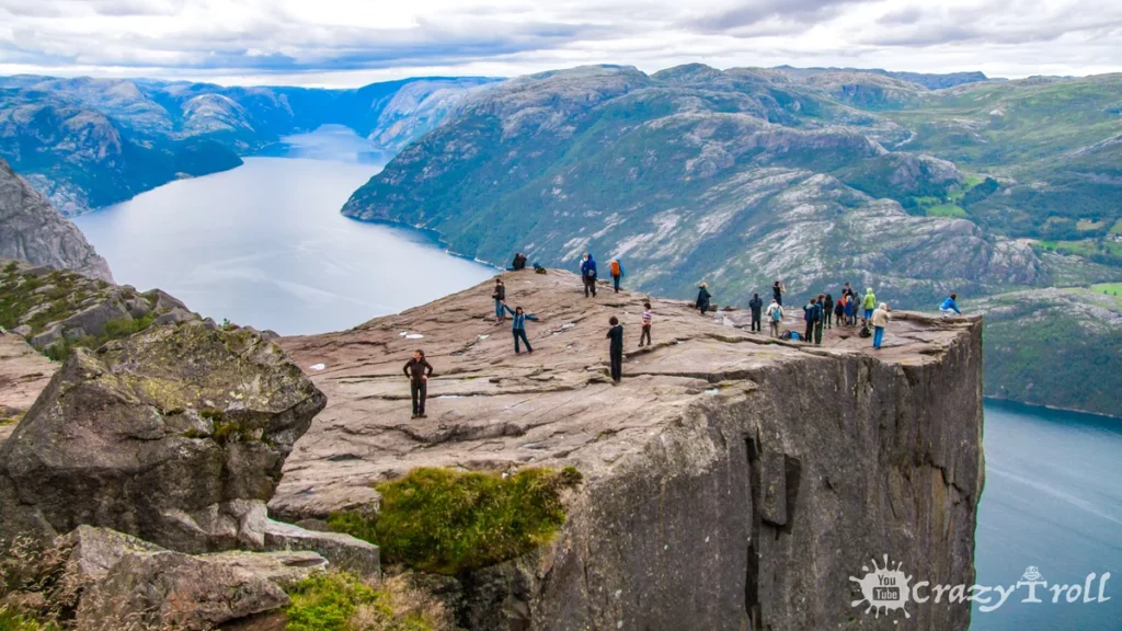
Preikestolen cliff
Preikestolen cliff
A giant cliff 604 meters high towering over the blue waters of the Lysefjord. Translated Preikestolen – “Preacher’s Pulpit” the top of the cliff is very flat and almost square with an area of 25 by 25 meters.
This is one of the iconic places in Norway and is visited by about 100,000 people a year. From the top of the cliff, there is a wonderful view of the mountains, the fjord, and the Kjerag plateau.
Interestingly, the edge of the cliff is not fenced off by anything, and it depends only on your courage how close you can get to the cliff to take a photo!
In 2018, the film Mission Impossible was filmed here and Tom Cruise performed dizzying stunts by falling off a cliff.
To get to Preikestolen, you have to walk along a mountain path. The elevation difference is 330 meters and the journey length is 3.8 kilometers one way. There are many signs on the trail and you definitely won’t get lost.
It’s also interesting that due to the change in altitude, the vegetation belts also change and from the dense forest at the beginning of the trail you will climb to the highlands, where only mosses and lichens grow.
Usually, the ascent takes from 1.5 – 2 hours. We recommend going in the morning and taking the whole day on this hike, as on the way to Preikestolen you will definitely meet many places where you want to stop and take pictures, you can also climb a little higher and look at the cliff from above!
And check the weather ahead of time, as the trail can be slippery in autumn or early spring.
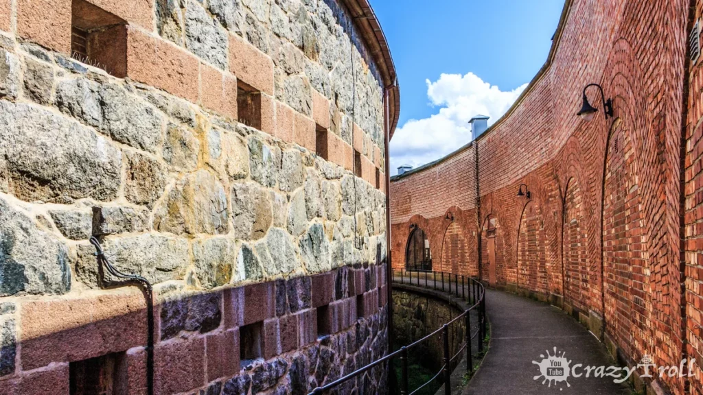
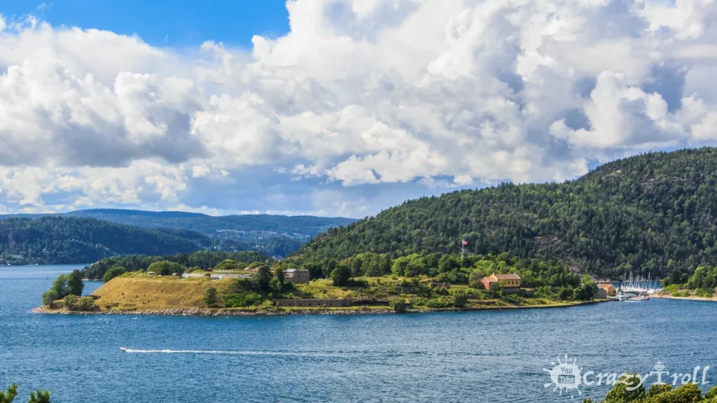
Fortress Oscarborg
Fortress Oscarborg
Just 40 kilometers from Oslo, at the narrowest point of the Oslo Fjord, the mighty Oscarsborg Fortress is located on two islands. The fortress was built in the middle of the 19th century.
The fortress played a key role in the detention of the German squadron in the early days of the German attack on Norway. On April 9, 1940, the German cruiser Blucher was sunk from the fortress. And it still lies at the bottom of the fjord not far from the fortress.
Oscarborg fortress in Oslofjord
Now Oscarsborg is a military museum. Picturesque nature, fascinating history, and the opportunity to unhurriedly relax from the bustle of the city. There are even sandy beaches and a great forest trail for walking. You can get to the fortress by ferry from the city of Drøbak.
We think this hidden gem right in the middle of the Oslofjord is hidden from most tourists. If you are interested in history, or want to get off the standard guidebook spots, then you should definitely visit this place!
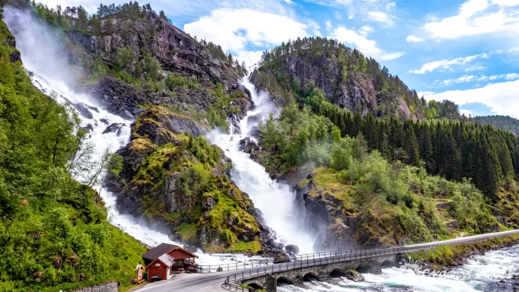
Latefossen waterfall
Latefossen waterfall near Odda
Twin Falls – Lotefossen, the famous Norwegian waterfall, can be admired on the way from Odda to Stavanger. After all, it is located right next to the tourist road number 13.
Water crashes down from a 165-meter-high cliff and goes under a stone bridge along which the road runs so that cars passing by get a fresh spray shower and it is important to ensure that the windows are closed.
Lotefossen differs from other waterfalls in the region in that it is divided into two parts by a rock. Tourists began to visit Lotefossen as far back as the 19th century, as the road that connected Eastern and Western Norway passed by. If you walk up the path, even the ruins of an old tavern remained there.
We believe that the perfect time to visit Lotefossen is the beginning of summer because then the snow is still melting in the mountains and the waterfall is especially full-flowing.
But be prepared for the fact that during the tourist season, the small parking lot near the waterfall is likely to be overcrowded.
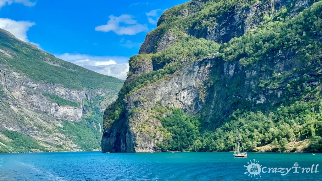
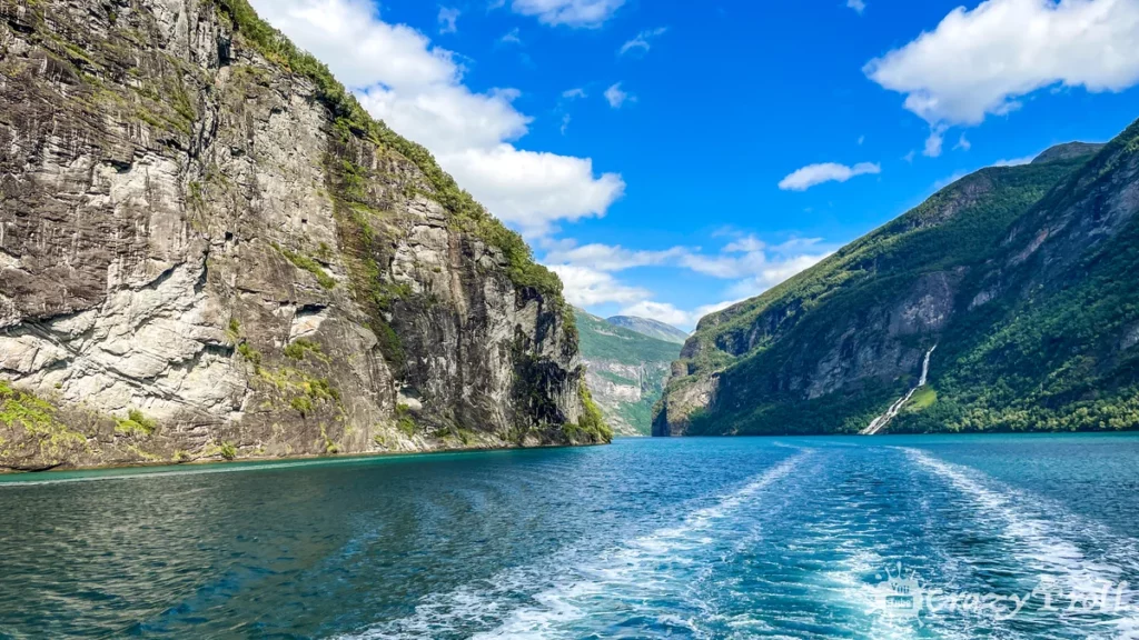
Fjord Geiranger
Geirangerfjord
Norway is one of four countries in the world that are located in the fjord region. So you simply must see the fjords of the western coast of the country. We highly recommend visiting the Geirangerfjord. Since 2005 it has been on the UNESCO World Heritage List.
The Geirangerfjord stretches 15 kilometers inland, and its depth reaches 565 meters. It is considered one of the most picturesque fjords in Norway due to the azure color of the water, sheer and very high cliffs from which mighty waterfalls break down. Along the shores, there are small farms with grass on the roof.
Cruise over Geirangerfjord
The best way to discover the beauty of the Geiranger Fjord is on a boat cruise. But there is an alternative – a viewing platform not far from the city of the same name Geiranger.
From the Ørnesvingen platform, you can see the waterfall of the seven sisters and the turn of the fjord towards the Akerneset mountain, the dark secret of the Geirangerfjord. Indeed, with external serenity, Geiranger is one of the ten cities in the world that can disappear at any second.
A crack in Mount Akerneset slowly grows, and the rock could collapse into the waters of the Geirangerfjord, covering the cities in the valley with a tsunami wave.
So hurry to see this beauty before the irreparable happened!
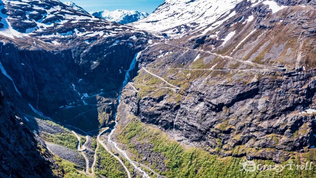
Serpentine Trollstigen
Serpentine Trollstigen
Trollstigen or the Troll Staircase is another visiting card of Norway, it is a serpentine road with 11 sharp turns and a rise of 9%. It is part of the popular tourist route on the RV63 road between Geiranger and Åndalsnes, and if you decide to go there, then know that there is no alternative route in the area, and the detour is extremely significant.
But the daredevils who decide to ride along Trollstigen will be rewarded with beautiful views of the mountains and valleys, and will also be able to visit impressive viewing platforms at the very beginning of the descent at an altitude of 858 meters.
Along the entire serpentine, the Stigfossen waterfall rumbles, its height is 180 meters, and at the bottom of the serpentine, there is a narrow Stigfossbrua bridge under which the waterfall goes, enveloping cars passing over the bridge with a cloud of spray.
We highly recommend visiting the Troll Staircase, as we consider it one of the most picturesque places in Norway, but be careful because in the autumn-winter period the Troll Staircase is closed to traffic.
Usually, this section of the road opens in the second half of May and closes in October, depending on weather conditions, these dates may be shifted.
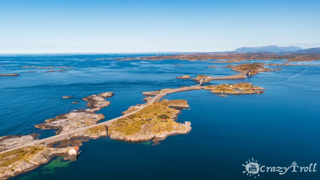
The Atlantic Road
The Atlantic Road aerial photo
The Atlantic Road is a 36 km section starting from the town of Bud. It is a component of the regional road 64, located between the settlements of Molde and Kristiansund. The Atlantic Road runs through numerous islands and islets in the Atlantic Ocean. For which it got its name.
This is one of the most famous and scenic roads in Norway. In total, there are 18 scenic routes in Norway, and this one is perhaps the most popular among tourists.
It is an unforgettable experience to drive a car along a winding road washed by the Atlantic Ocean and cross the longest and most impressive of the eight bridges on this road, the Storseisundet Bridge, whose length is 260 meters.
Along the entire road, there are many parking lots and resting places to stop, admire the color of the water and sea birds, and walk along the road along the rocky shore.
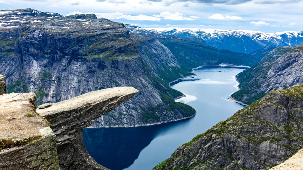
Trolltunga
Trolltunga
Troll’s Tongue is a broken piece of the Skjeggedal mountain, frozen on its edge in a horizontal position at a height of 700 meters. The shape of the protrusion resembles a tongue, for which it received its name. It is located near the city of Odda.
From the Trolltunga, you can enjoy a wonderful view of Lake Ringedalsvatnet and the mountains surrounding it, and you will get an unforgettable experience of mountain adventure and adrenaline with every step along the cliff to its edge.
The path to the Troll’s Tongue will be mastered by experienced travelers with good physical fitness, as the circular route is more than 20 km with sharp rises and the recommended time for the hike is 8-10 hours. So if you want to visit the Troll language, better prepare in advance and test your strength on a hike to Preikestolen.
Also during the tourist season, due to the popularity of the place, there are queues of tourists who want to take pictures in the Troll Language. And those lines can easily take a couple of hours, so leave early and plan on hiking all day long!
The recommended time to visit is from June to September, as the trail can be slippery at other times. Yes, and in early spring and late autumn it gets dark earlier, you just may not have enough daylight hours for the route there and back.
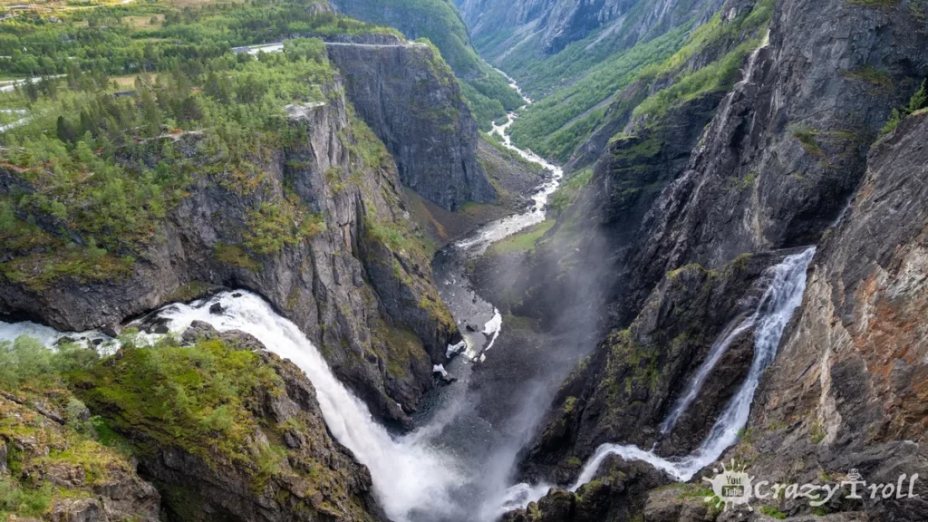
Vøringsfossen waterfall
Vorinfossen waterfall
Vøringsfossen is the highest freefalling waterfall in Norway. Its total height is 182 m, and the height of the free fall of water is 145 m. Interestingly, this is the rare waterfall that, regardless of the time of year, always has a flow force, since the water level in the river is regulated power plant and set a minimum water flow of 12 m³ of water per second during the summer season.
You can view the waterfall from the top or bottom point. The upper observation deck is located on the Hardangervidda mountain plateau and has a convenient free parking lot with a short path to the observation deck.
In 2020, a very unusual pedestrian bridge was built here right over the abyss between two sheer cliffs, the height difference of which is 16 meters. So it’s definitely worth stopping by and checking yourself out by walking along with the 99 steps of the bridge.
To visit the lower observation deck and see the streams of water up close, you need to go down to the valley and walk one and a half kilometers along the hiking trail along the Bjoreio River.
Start of the hiking trail between the second and third tunnels of the R7 road. There is also parking for cars. Follow the signs and descend into the canyon, and then along the river to the waterfall. The level of difficulty is medium and it is better to bring comfortable shoes with you!
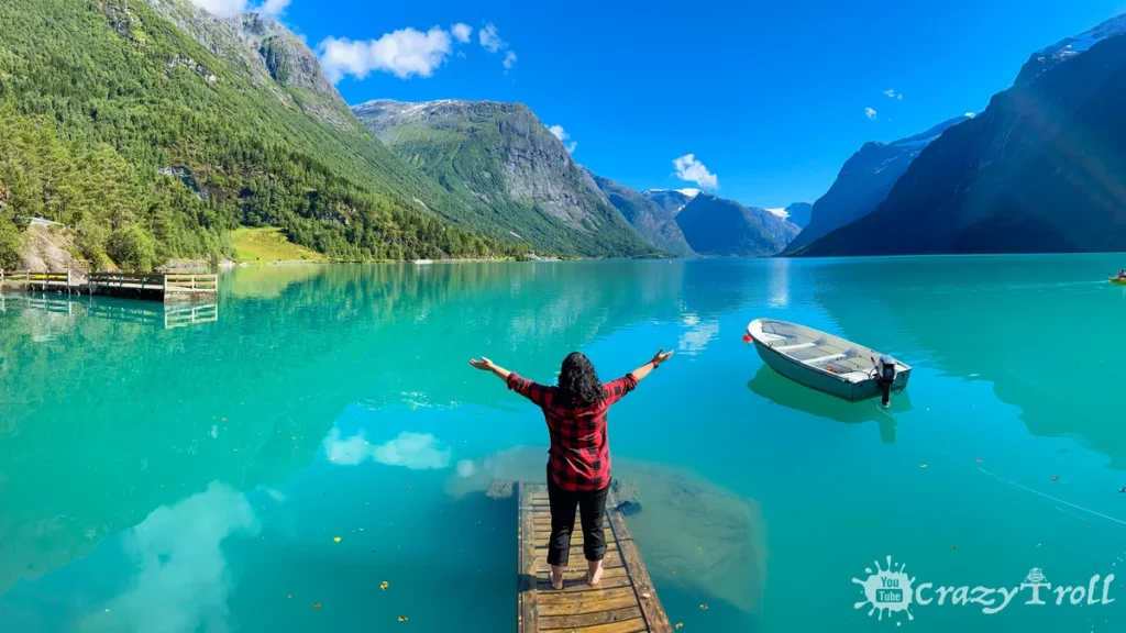
But beautiful landscapes are side by side with a dramatic history. In the previous century two tragic landslides occurred here, as a result of which giant waves formed, which destroyed the settlements of Nesdal and Bodal, and also took the lives of 135 local residents. But now this place attracts true connoisseurs of nature, as here it has been preserved in its original form.
Mighty mountains with white glacier caps and dense forests on their slopes are an excellent addition to the blue waters of the lake. Everyone who loves fishing will be pleasantly surprised by the fact that it is allowed to fish in the reservoir for free.
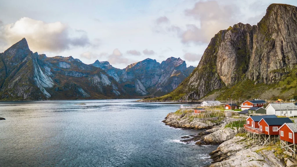
Lofoten Islands
Lofoten Islands
Lofoten is an archipelago located in the Norwegian Sea in northwestern Norway. Lofoten consists of many islands, the coastline of which is indented with bays and a variety of beaches from rocky to sandy.
Also, the main craft of the inhabitants of the Lofoten Islands is fishing, so there are many cozy villages with moorings for boats and there is even a Museum of Dried Cod.
But still, the main feature of a holiday in Lofoten is solitude, silence, tranquility, and wild, untouched nature. Despite the geographical location of the islands, the weather here is relatively warm. This is due to the close proximity of the warm Gulf Stream.
People come to Lofoten to see whales, go fishing, hike in the mountains or watch the Northern Lights. Polar surfing is also atypical entertainment on the islands!
After all, if you have a good wetsuit, the climatic conditions here are as comfortable as possible for surfing, though if you immediately go to the bath to warm up. Since the water even in the hottest time here does not happen more than +15 degrees.
Beginners come here in June, July, and August, and in winter only real professionals ride here.
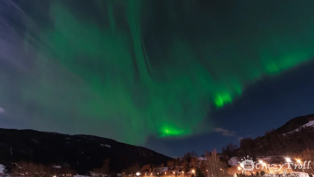
Northern Lights in Tromsø
Northern Lights in Tromsø
Many people associate Norway with the northern lights, but in order to increase your chances of seeing it, you need to be in Norway during the northern lights season from about September to April, when the sky is dark and daylight hours are short. And also go as far north as possible.
The city of Tromsø is considered the Norwegian capital of the northern lights, it is quite northern and there is an airport where it is convenient to fly. But it is still important to check the weather forecasts because if there are clouds in the sky, you will not see the aurora.
We highly recommend visiting Norway during the northern lights period, because watching with your own eyes the magical dances of green lights in the sky is an exciting and fascinating experience that you will definitely remember for a lifetime!
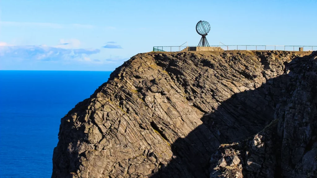
Cape Nordkap
Cape Nordkap
North Cape is a huge granite rock with deep cracks along the edges. The height of the cape is 307 m. The upper part of the North Cape is flat, covered with rocky tundra with small lakes. The cape got its name due to its location – in the very north of Europe.
It is often also considered the northernmost point in Europe, but this is not so, because the cape is located on an island, so it is only a tourist place with an observation deck on the waters of the Barents Sea.
North Cape is located far beyond the Arctic Circle. In winter, you can go dog sledding here, and in summer you can enjoy the midnight sun and admire the nesting of large colonies of various Arctic birds.
But fishing on the North Cape is a year-round hobby, so you can come to the cape any month. The polar day from May 13 to July 31 is also clearly visible here when the sun does not set but shines around the clock. Well, the polar night begins from November 21 to January 21 and the sun does not rise.
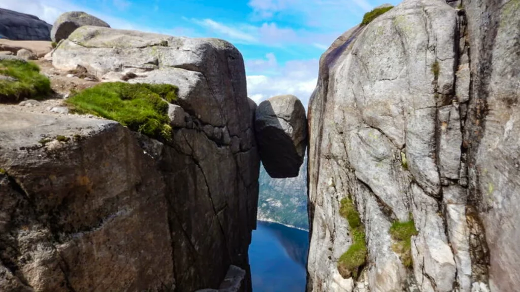
Kjeragbolten – the stone hanging over the abyss
Kjeragbolten – the stone hanging over the abyss
Kjeragbolten is a round boulder measuring 5 m3, which is stuck between the rocks above a precipice at a height of 984 m. And only the brave will be able to step on it and look down confidently smiling for an iconic photo from a place that can definitely be considered the hallmark of Norway!
The Kjerag plateau is located in the Rogaland region at the very end of the picturesque Lysefjord fjord.
But the path to the stone is not easy and will take about 5 hours in both directions. It will also require you to have a good level of physical fitness, as there are steep ascents and descents on the trail, where you will need to hold on to the chain. And the length of the path in one direction is about 5 km.
And obligatory check the weather because the hike to Kjeragbolten is a summer hike and the trail is considered safe from June to October. Also, fogs are quite often on the trail in autumn.
But Kjeragbolten is worth getting ready and going! The views of the surrounding mountains against the background of the blue waters of the fjord are impressive, and the stone itself looks very unusual, and there is a legend among the Norwegians that real trolls threw it there!
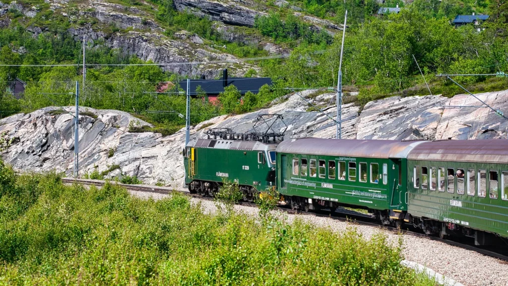
Flåm train
Flåm train
If you love mountain trains and adventure, then you should definitely visit the railway in Flåm. After all, this route can rightfully be considered one of the most beautiful railway routes in the world and certainly the most beautiful route in Norway.
Within an hour, the train will take you from the level of the Aurlandsfjord to the mountain station Myrdal, located at an altitude of 867 meters above sea level.
Another interesting feature of the Flåm railway is that it is considered one of the steepest railway lines in the world, as 80% of the track passes with a slope of 5.5%.
The views from the train window are spectacular, along the way the meadows will be replaced by dizzying mountain slopes and seething waterfalls, and you will also pass through 20 tunnels, 18 of which are built by hand! And most importantly, a trip to Flåmsbana is a trip into Norwegian nature with a stop near the mighty Kjosfossen waterfall in the middle of the way.