You have arrived in Norway at Gardermoen Airport and want to see all the highlights that the country is associated with Glaciers, Mountains, Fjords, High Altitude Roads, and Blue Lakes!
As well as to add something unknown, which, due to the monotonous information on the Internet, tourists miss and only locals know? Then this itinerary is for you!
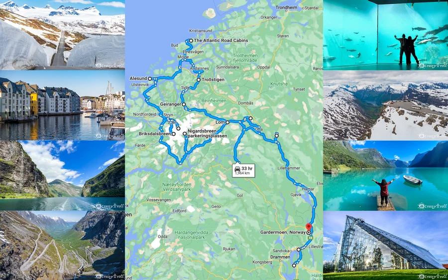
A full 2-week route in Norway from Oslo
We live in Norway and in this itinerary, we have combined our favorite tourist and non-tourist but no less beautiful places!
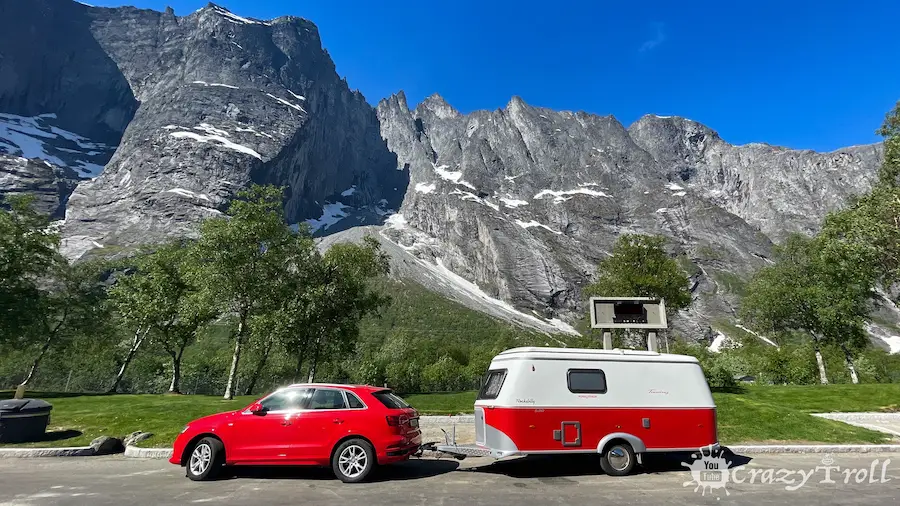
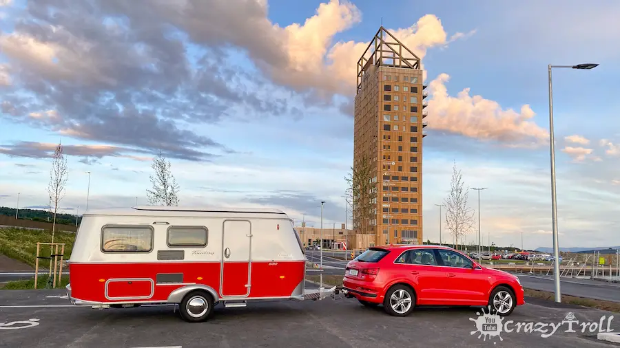
The route is designed for 14 days for travelers by car or with a caravan and its length is 1980 kilometers, BUT you can choose what you want to see and what you leave for the next time!
Well, if you have any questions feel free to write to us and we will suggest the best solution!
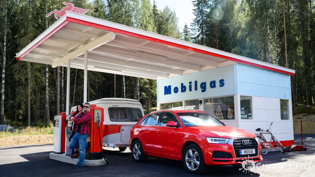
Day 1: Oslo Airport – Hafjell (170 km)
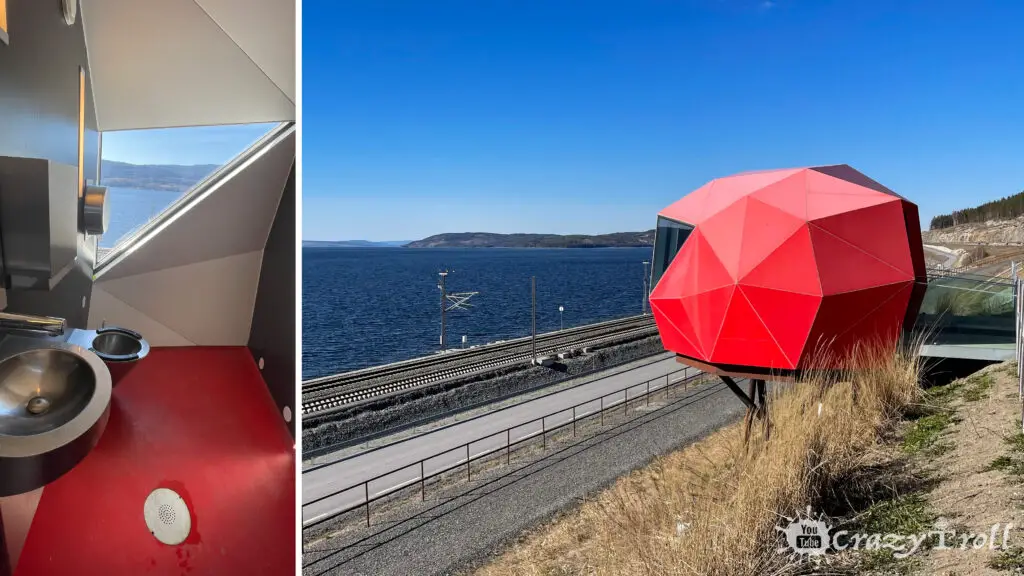
You arrived, left the airport, and drove already 50 kilometers, which means you, or someone in your car definitely wanted to … toilet.
And yes, no matter how strange it may seem, we will begin our acquaintance with Norway with the toilets. There is definitely something wrong with them, they are beautiful!
Rest place with a modern toilet in Norway
And sometimes you even want to settle in them! And one of these toilets is located at a resting place near the E6 highway! Beautiful view, stylish design and it’s all completely free! Recommended to visit, well, or just warm up and enjoy the views of Norway’s largest lake Mjøsa, its area is 365 square kilometers.
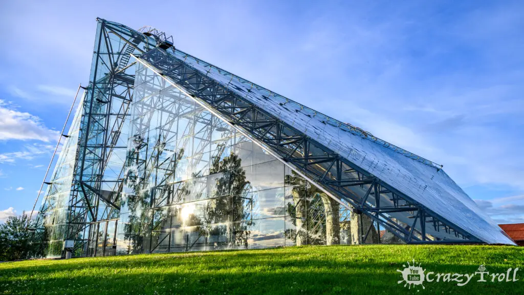
Your next stop will be in the city of Hammar and we recommend visiting one of the most unusual museums, Domkirkeodden.
In addition to the beautiful old buildings from the villages of Hedmark, you will see a futuristic glass structure here, which, oddly enough, fits perfectly into the flavor of the place. It covers the ruins of an ancient cathedral and is the main attraction.
All visitors to the museum can experience fantastic acoustics, and local guides are willing to show off their singing skills. There is also the largest ecological herb garden in the country.
In general, the museum gives an excellent insight into our history from the Viking Age to the Middle Ages to the present day.
Adult
140 NOK
Children age 6-15
70 NOK
Children under 6
0 NOK (Free)
Seniors/ Students
110 NOK
Working hours: 11 – 16 Tuesday – Sunday, (Closed on Monday)
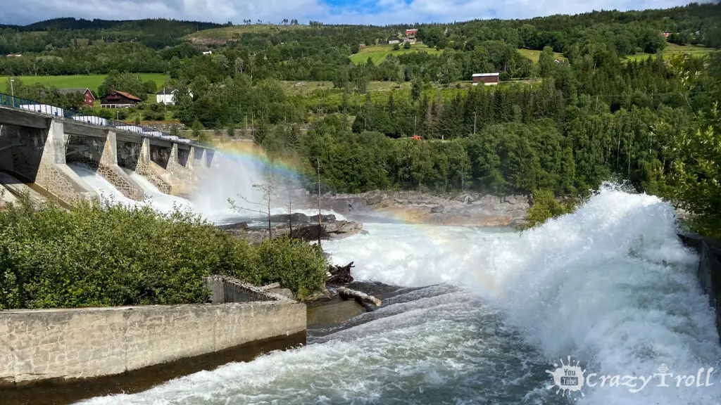
Norway is one of the European leaders in the production of hydropower. And this is all thanks to numerous natural reservoir lakes on high plateaus, waterfalls, and rivers. That is, what we think is beautiful and for the sake of which we go to Norway is also beneficial.
Why not take a walk along one of the hydroelectric power plants located on the blue river Lågen? Especially since she’s on her way!
It’s completely free, legal, and undeniably impressive in the moments when excess water is dumped. So we recommend walking along the top of the dam, 158 meters long and 16 meters high.
In Norway, many tourists note the excellent quality of the roads, and we think you are satisfied with them after driving more than 160 kilometers! We invite you to visit the Norwegian Roads Museum.
You still doubt it, but how do you argue that the museum is completely free and open all year round? The museum offers interesting adventures for the whole family and tells the story of the roads!
The Norwegian Road Museum also includes the Norwegian Museum of Vehicle History and the Norwegian Blasting Museum. It is one of the largest museums in Norway and has several thousand square meters of indoor exhibitions as well as a large museum park.
Working hours: 10 – 15 Tuesday – Sunday, (Closed on Monday)
In the city of Fåvang, near the E6 highway, there is a sculpture – “Mammoth”. This is a double-size replica of a mammoth skull. You can stand by and realize how huge they were! By the way, earlier in the Fåvang area, several most valuable finds related to mammoths were made.
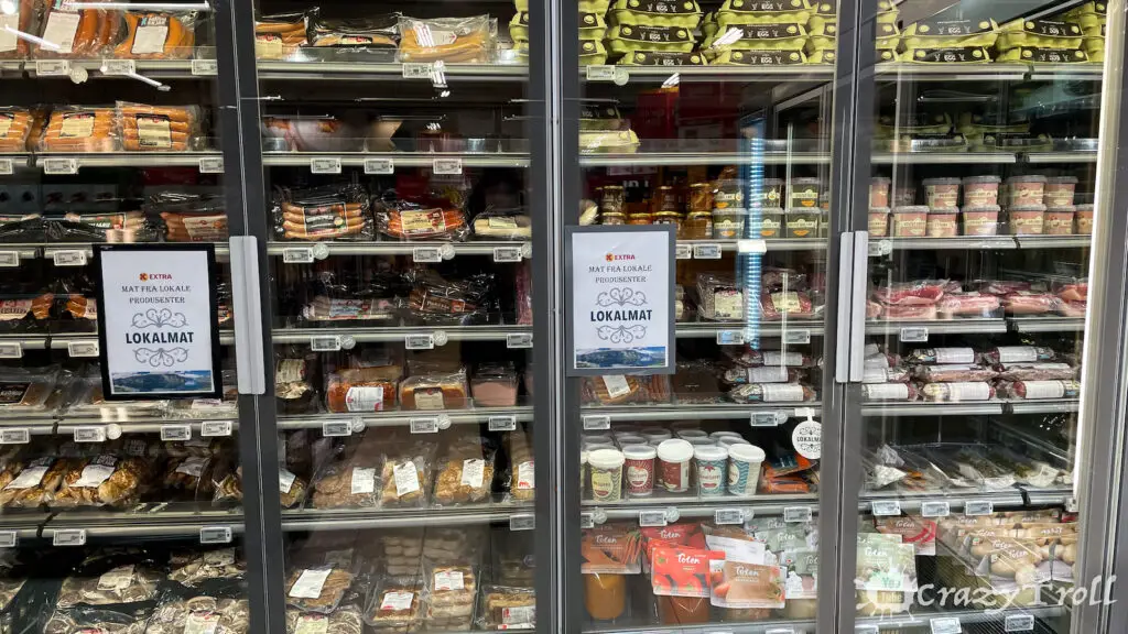
There is also a chain store “Extra” very close by, it would seem, nothing unusual. But we advise you to look into it, as there is a large department of local delicacies “Lokal Mat”.
Local food – cheese
There is everything from tea, jam, and waffles to cheeses, sausages, soups, and ice cream. If you love cheese, we sincerely recommend trying our favorite “RørosOst med røkt reinkjøtt” which is a local cheese with reindeer meat.
There is another secret place near the E6 highway, where you pass your way, where you can take a short walk, warm up and enjoy the beauty of Norwegian nature combined with modern art.
Oktagon is the embodiment of the imagination of architecture students, these are two octagonal installations: one is located at the transition between land and water, and the other with a wonderful view of the valley and the river.
With their installation, the creators wanted to slow down the pace of your life a bit and give you the opportunity to enjoy nature. And going a little further you will see the beautiful sheer cliffs of Klokkarstranda.
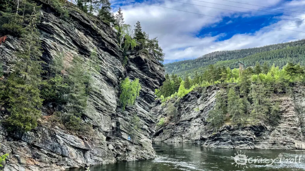
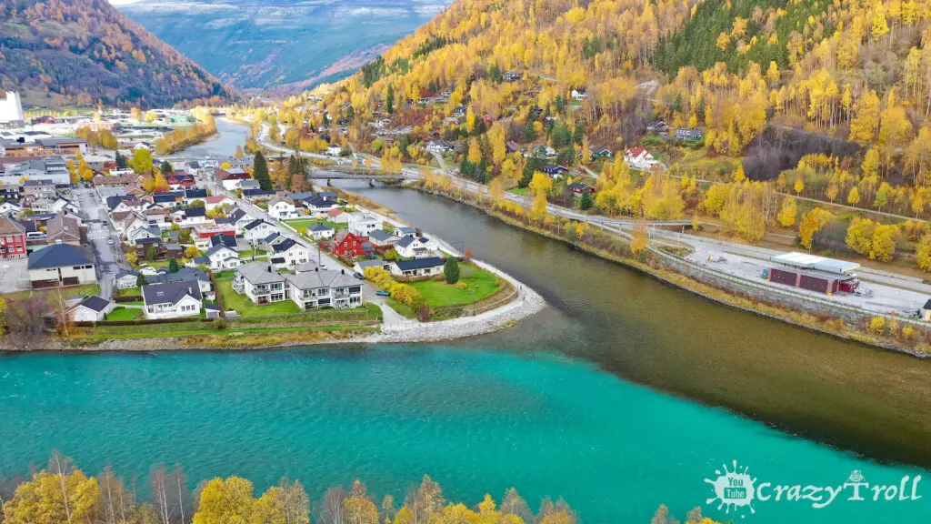
The city of Otta is located on the turnoff from the E6 highway to Rv15. Here you can see the meeting of two very different in mood and colors rivers Otta and Lågen, this is an unusual and very picturesque natural phenomenon.
Their waters meet and get to know each other in a beautiful dance of colors and shapes, against the backdrop of the majestic mountains of the Selle region. Stop, walk along the promenade and admire for yourself!
By the way, you can also look at the meeting of two rivers from above. Above the city there is a serpentine Rondanevegen. And at its second and fourth turn there is an opportunity to stop and look down because the city of Otta is visible from here in full view!
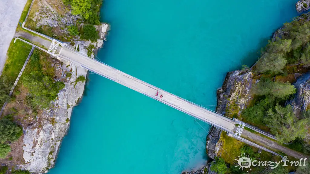
Traveling along highway number 15, you will be surprised and delighted by the color of the water in the river. We recommend visiting the suspension bridge over the very blue river Finna in the Ottadalen valley.
It is located next to highway number 15. There is excellent parking and cozy tables, so be sure to stop, enjoy the color of the water and take a couple of beautiful photos!
Mount Blåhøe with a height of 1617 meters. From the top you have panoramic views of the famous national parks around Jotunheimen, Rheinheimen, Rondane, and Dovrefjell, as well as the villages of Dovre, Lesja, Sel, and Vågå.
The road itself is the third highest road in Norway. It is a gravel road 12 km long. The entrance is paid and costs 50 crowns. The views from the top are amazing! But don’t forget to check the weather, and bring warm clothes with you, then your trip will be as safe and comfortable as possible!
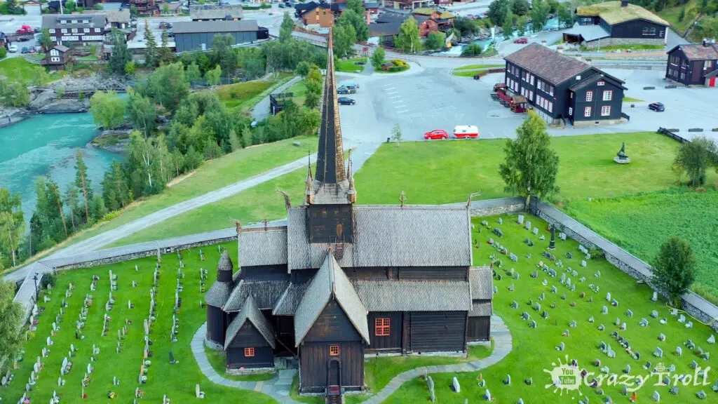
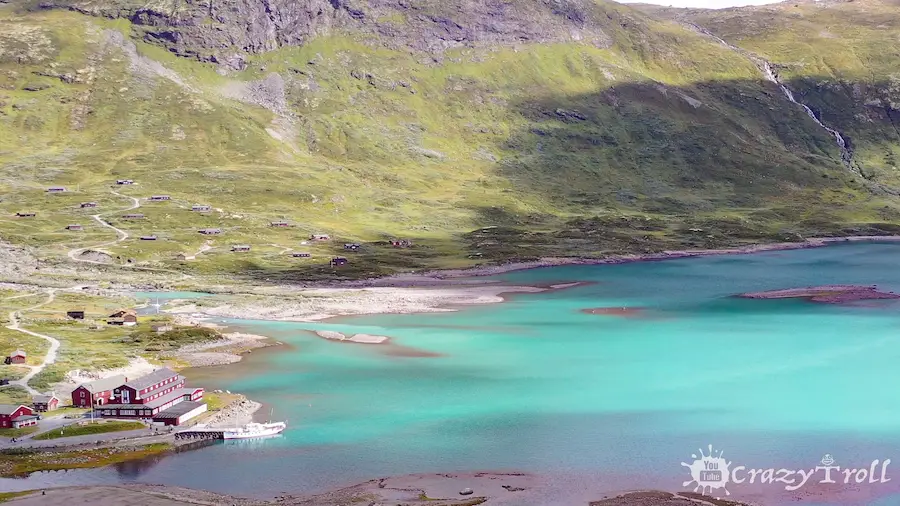
The beautiful and cozy center of Loma is full of life during the summer months. After all, this city is considered the gateway to the national parks Jotunheimen, Breheimen, and Reinheimen.
Here you will find everything from a famous bakery, cafes, and restaurants to shops, museums, and an ancient stave church from 1160.
We recommend that you visit it, because it is one of the largest wooden churches in Norway. Just such architecture of churches is classical for the oldest wooden churches.
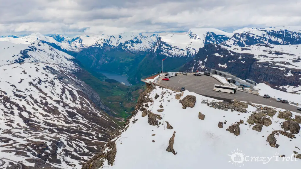
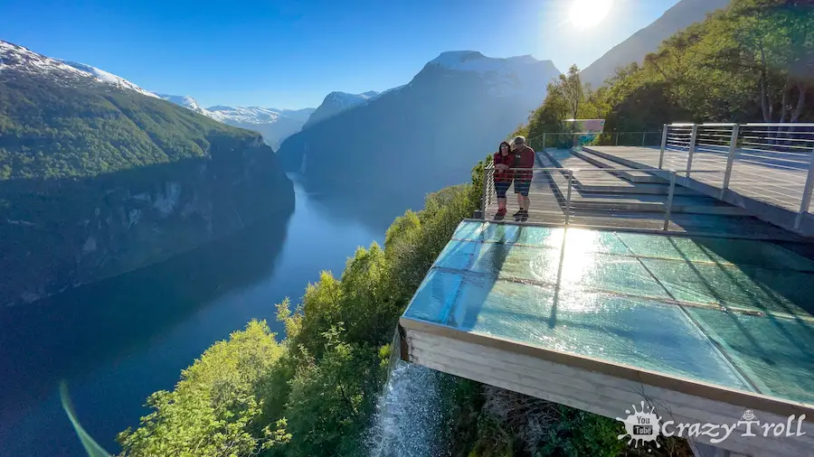
Dalsnibba is an observation deck at an altitude of 1476 meters. And it is located on a sheer cliff above the abyss. From here, a majestic panorama of the Geiranger fjord and mountains with snowy peaks opens up.
On a toll road – a serpentine road to Dalsnibba can be reached by car. And admire the highest fjord view in Europe from the road. Despite the fact that the observation deck is located on a high mountain, the parking lot here is large and there is enough space for everyone and cars, and even large tourist buses. Also upstairs there is a cozy cafe, gift shop, and toilets.
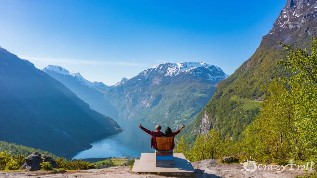
On the descent to the city of Geiranger, we recommend stopping at the observation deck Flydalsjuve. After all, it is from here that most of the Internet photos of Geiranger were taken. The observation deck is divided into two areas: upper and lower, and a path is laid between them.
On the bottom is an installation called “Fjordsetet” (“Place of the Fjord”), unveiled by HRH Queen Sonja. People call this installation the Queen Sonja Chair. And from here a truly royal view of the fjord opens!
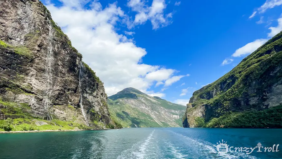
Geiranger Fjord is probably the most famous fjord in Norway and the world. After all, it is here that high and sheer cliffs meet the sea. The fjord is 15 kilometers long and it is best to get acquainted with it from the water. There are various options for how to do this and we talk about them in more detail in our article.
But, whether you choose a kayak tour or a ferry cruise, we are sure you will be impressed by the fabulous landscapes of high mountains, on the steep slopes of which small farms are located. And from their peaks, the mighty waterfalls “Seven Sisters” and “Bridal Veil” break down with a roar.
Try to be in Geiranger as early as possible, then you will have more alternatives to sea travel.
An eight-kilometer serpentine road of eagles (Ørnevegen) leads from Geiranger. It consists of nine turns and in some places, the slope of the road reaches 10%. At the highest turn, a small but very cozy observation deck was built through which a waterfall flows.
The observation deck offers a wonderful view of the famous Seven Sisters waterfall, the Geiranger fjord, and the city.
The stop will not take much time, but it will give you a lot of vivid impressions and good photos!
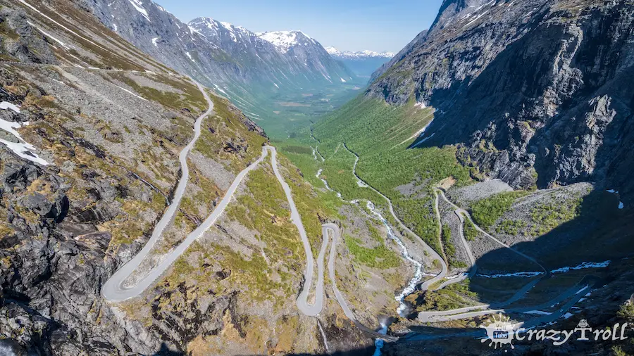
Trollstigen is probably one of the most famous and recognizable roads in Norway! Tourists from all over the world dream of riding it, but at the same time they are afraid of meeting the steep and narrow mountain serpentine!
Trollstigen was discovered in 1936, but can still serve as an example of engineering and design art! The serpentine consists of 11 sharp turns and the slope of the road in some places reach 9 percent.
The road is surrounded by majestic and sheer peaks and along all the turns a waterfall rumbles.
From above there are stylish and comfortable viewing platforms and a walking path, as well as shops and a toilet.
We can just as confidently add that the descent along the Trolls road is a real adventure that every traveler must experience!
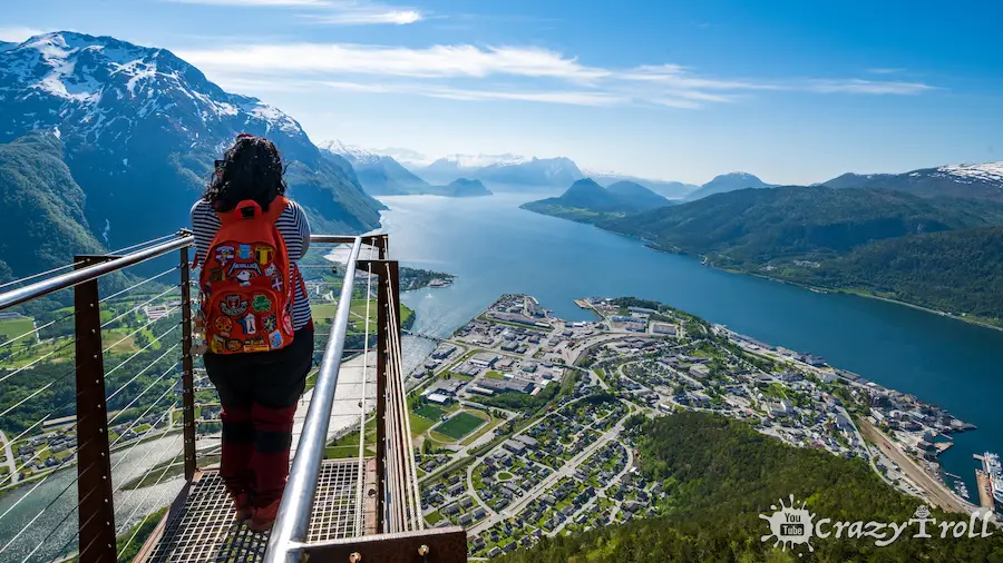
Åndalsnes is a small but very cozy town on the banks of the Romsdalsfjorden. It is surrounded on all sides by mighty mountains. And each street in the city is picturesque in its own way, and looks like a picture from a guide to Norway!
After all, colored, wooden houses against the backdrop of high and snowy peaks are one of the visiting cards of the country.
Also here on the waterfront is the Norwegian Climbing Museum (Norsk Tindemuseum), where you can study the history of the development of mountaineering from the very beginning to the present day.
Near the town of Åndelsnes, the bright blue River Rauma flows into the fjord. And on its shore, there are many campsites and places of recreation for tourists.
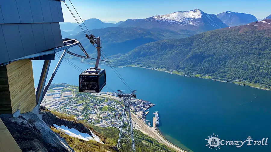
Rumdalgandolen is the longest cable car in Norway, the idea of construction appeared in 1964. The ascent takes about 5 minutes. The maximum speed is 10 m / s, and the rise reaches 73 percent. The trailer is designed for 45 people and leaves every half an hour, but when there are queues and during the season, more frequent lifts are promised. Upstairs is the Eggen restaurant with breathtaking panoramic views in all directions.
The cable car will take you to the Nesaksla mountain, where you can visit the Ottarbu stone house at an altitude of 708 meters. Also from there you can go hiking to the popular and most recognizable viewpoint of Åndalsnes – Rampestreken.
The Rampestreken lookout is a fantastic experience and uniquely vibrant experience. It is located at an altitude of 537 meters above sea level. And the view from it is definitely worth it to go on this hike! From the starting point in the center of Åndalsnes, there is a trail with a constant climb to the Rampestreken lookout.
The hike is classified as moderate, but the last leg is quite steep. When you reach about 430 m above sea level, the nature trail turns into stone steps and the path becomes more comfortable.
These steps were made by Nepalese Sherpas and this part of the trail is called Romsdalstrappa. The entire route is perfectly marked with signs and red signs on trees and rocks. Also every 100 meters there are altitude indicators.
But remember that you have an alternative and you can climb the Nesaksla mountain to Rumdalgandolen and then go down to Rampestreken along the trail. This path will take much less time and require less effort.
The Troll Wall is a section of the Trolltinden mountain range. It is located on the west coast of Norway in the Romsdalen valley. The height difference of the wall from the bottom of the valley to the top is 1700 meters, and the height of the vertical section of the wall is about 1000 meters, which makes it the largest in Europe.
It is also a very visited tourist place in Norway because it is located along the way and there is wide and convenient parking, as well as picnic tables. We recommend taking something to eat with you or going to a cafe, which is located in the tourist center of the Troll Wall.
By the way, this cafe was included in the list of the most beautiful restaurant designs in 2013.
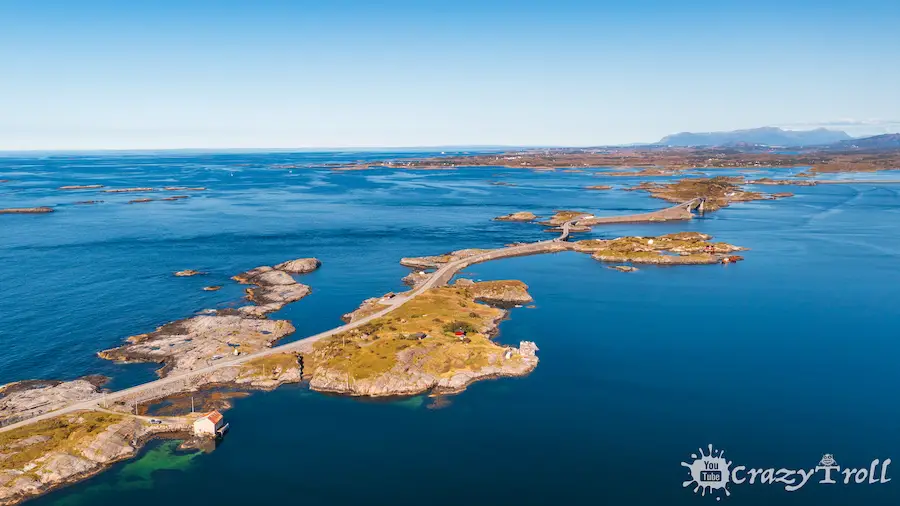
Day 5: Åndalsnes – The Atlantic Road – Ålesund (236 km)
The Atlantic Road
The Atlantic Road
The Atlantic Road runs through numerous islands and islets in the Atlantic Ocean. For which it got its name. This is one of the most famous and scenic roads in Norway. It is an unforgettable experience to drive a car along the road washed by the ocean and cross the longest of the eight bridges on this road, the Storseisundbrua bridge. Along the road, there are observation platforms and places for stops and rest.
But of course, for the sake of the Atlantic road, we will have to make a separate circle of more than 200 km. Also, for many, it causes a double feeling or does not even live up to expectations.
But we were obliged to include it in the route, but you can decide whether to go or not by watching our video in which we figured out why it is so good and whether it has more affordable alternatives.
Ålesund is one of the most atypical and architecturally stylish towns in Norway, it is even called the Venice of the North. By the way, the characteristic architecture of the city was literally born from the ashes.
On January 23, 1904, a fire broke out in the city, destroying 850 houses, that is, more than 80% of the city. Thanks to the efforts of local residents and patrons, the city was completely restored in less than 3 years.
Young Norwegian architects worked on the restoration, inspired by the Art Nouveau architectural trend that was fashionable at that time. Thus, a completely unique city on the water was born, the architecture of which harmoniously blended into the harsh beauty of the Atlantic.
After walking around Ålesund in the afternoon towards the evening, we recommend that you climb Mount Aksla. This can be done on foot from the city center by breaking 418 steps.
It is the same with a car, the road is not wide, but there is parking at the top. From the observation deck on Ålesund, the very view from the postcards opens up, and the sunset over the ocean fascinates and creates a special romantic mood.
At the top of the mountain, there are many hiking trails, picnic areas, and benches. So you will definitely find a place to your liking!
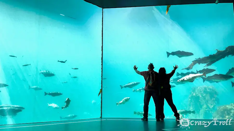
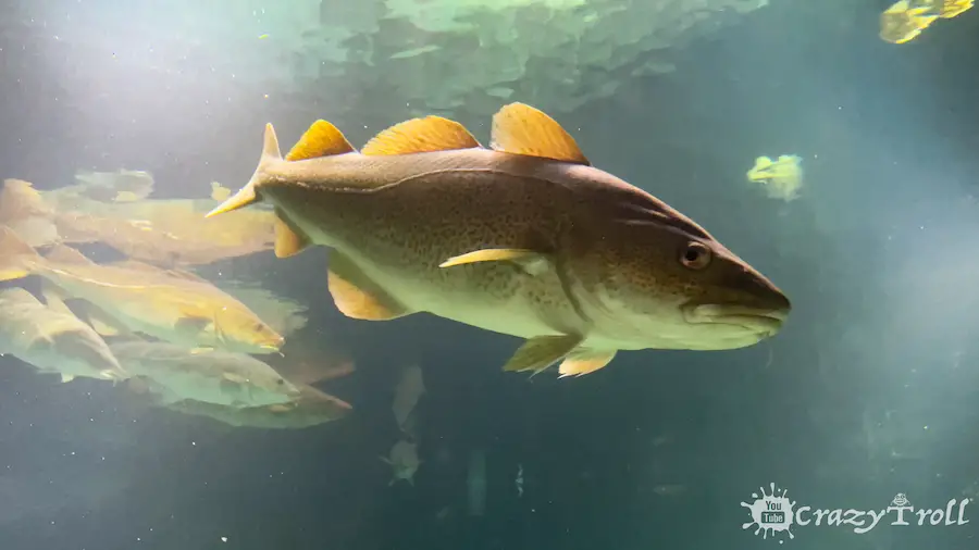
The aquarium in Ålesund is unusual in that it shows the inhabitants of the ocean along the Norwegian coast. There is also the largest saltwater aquarium in Northern Europe.
An interesting fact is that the volume of this aquarium is 4 million liters of real unfiltered sea water, which is pumped out 800 meters from the shore at a depth of 45 meters. That is, the quality of the water here is the same as in the sea, and large species of cold-water fish such as cod or pollock swim in the aquarium.
Also in a special room, there are no deep tanks, with marine inhabitants which you can touch and find out what they are like to the touch.
The outdoor part of the exposition includes penguins, seals, otters, and fur seals. They have spacious enclosures and special feeding hours. So come to the aquarium in the morning so as not to miss anything interesting!
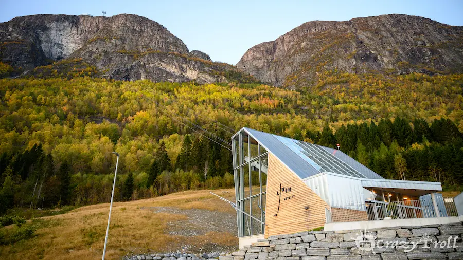
Loen Skylift is one of the coolest cable cars in the world! In 6 minutes, it will take you from the fjord itself to a height of 1011 m, to Mount Hoven. From above, you can enjoy an unforgettable view of the Nordfjord, glaciers, and mountain peaks.
nd also take a walk along one of the many routes for every taste and level of difficulty or have dinner in a restaurant. There is also a wide observation deck, from which, as in the palm of your hand, you can see the famous blue lake Lovatnet.
Also, if you wish, you can make a circular route. For example, take the Sky Elevator to the top, and go down on foot along a convenient road. Along the way, you can visit the village of Rakssetra, a postcard place of grass houses on rooftops against the backdrop of a fjord and mountains.
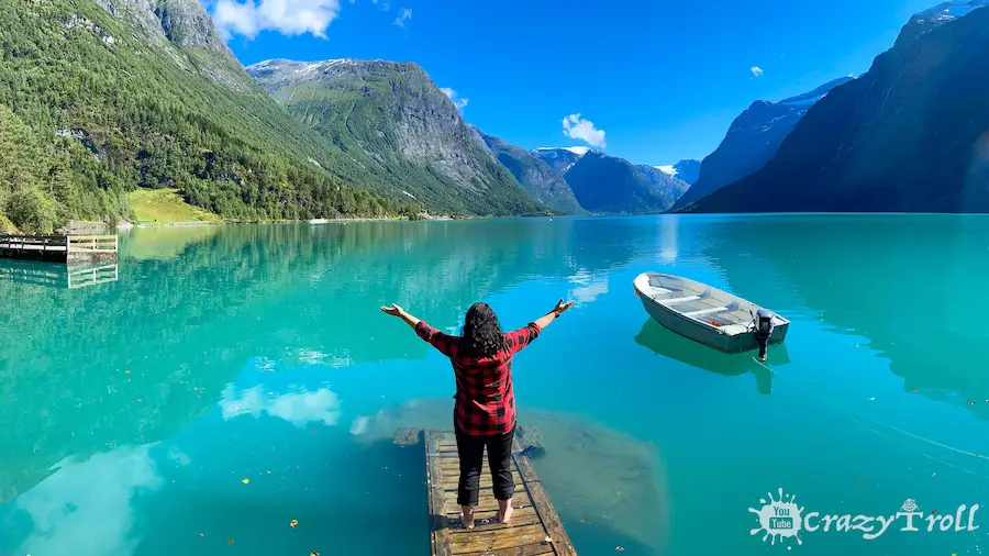
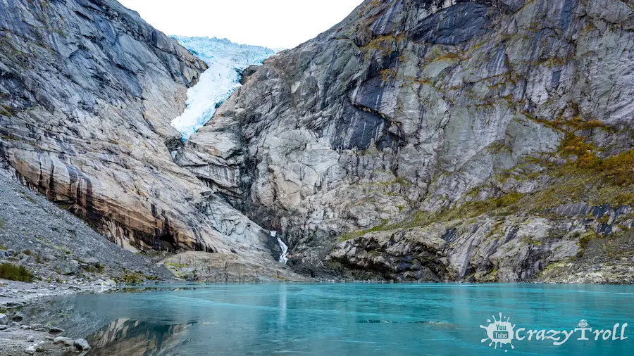
The glacial lake Luvatnet is located 2 kilometers southeast of the village of Loen. It is surrounded by mighty mountains and glaciers, and trout swim in its waters. But tourists are attracted here by its color, which is very turquoise and rich. But if you are traveling with a caravan, it is better to leave it at the campsite, and by car, be prepared for the fact that the roads along the lake are narrow, with places for traveling.
Many photos are taken on its banks, but there is a secret place here with a small bridge leading into the blue waters, as in our photo. If you are wondering why the water has such a color and where the very bridge is located, then we recommend watching our video.
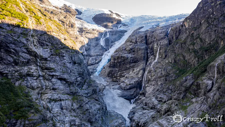
At the very end of Lake Luvatnet, the Kjenndalen valley begins, narrow and with very high mountains. This part of the road will be paid, you can pay by card the price of 50 kroons.
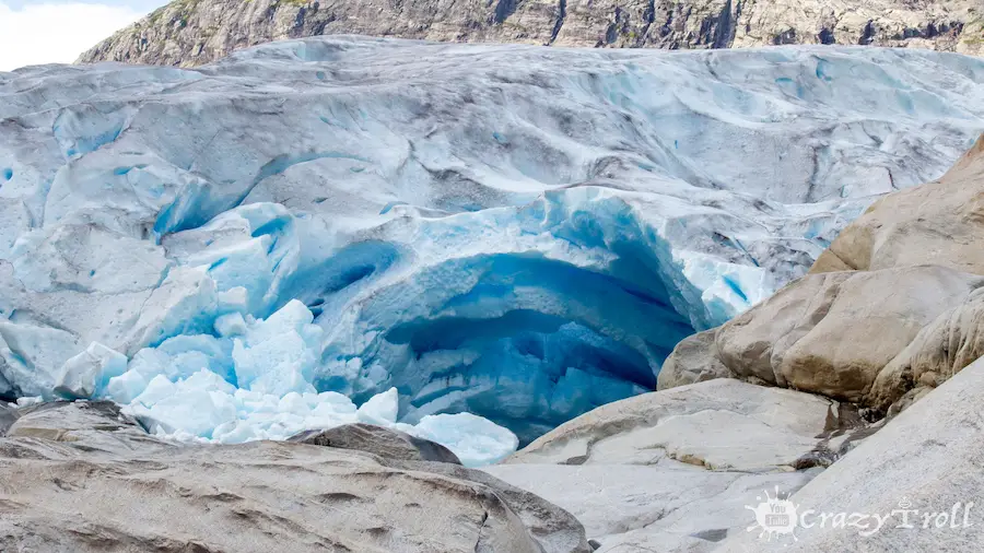
We invite you to take a walk from the parking lot to the lowest descent of the Jostedalsbreen glacier – Kjenndalsbreen. The walk from the parking lot will take no more than 15 minutes.
The trail is comfortable without strong ascents or descents. It goes along the rocky turquoise river. In general, in recent years, glaciers have been melting a lot, and we recommend that you always take binoculars with you on walks to the glaciers.
Since the glaciers are still located at a considerable height and distance, and so you will be better able to consider their unique structure and see the magic of ancient ice.
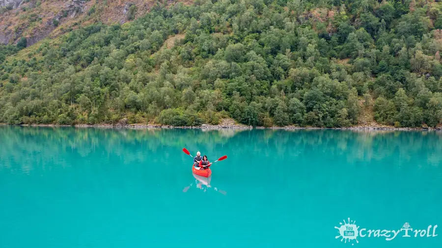
If you are impressed by the blue waters of Lake Luvatnet, we recommend visiting the less touristy but no less beautiful Lake Oldevatne. In general, visiting the blue lakes, of course, you will want to ride on them in a boat or kayak. You can rent expensive kayaks and boats, but on the blue lake ,Oldevatne you can do it for free!
Stay at one of the campsites like Oldevatn or Gritta camping – they offer their guests this activity and it’s already included in the price! Life jacket and paddle will be given to you at the reception!
We guarantee that kayaking on blue water, which on a sunny day seems to glow from the inside, will be a vivid experience for a lifetime!
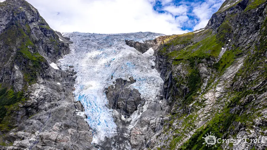
At the end of Lake, Oldevatnet is the Briksdalsbreen glacier, this is one of the most visited glaciers in Norway, as excursions are carried here from cruise ships coming to the port of Olden.
That is why there is an unusual service from May to October – a trip to the glacier on Trollcars. But in May and October, you need to book your trip in advance.
You can also walk to the glacier. The trail is 3 km long with a gentle ascent, along the way you will pass over the old bridge and see the beautiful Kleivafossen waterfall. The glacier descends from a height of 1200 meters into the beautiful Briksdalen valley with a turquoise glacial lake.
Also for lovers of more difficult routes from the valley, there are several more trails to the Melkevoll and Brenndal glaciers.
One of the most accessible and spectacular is the Bøyabreen glacier. After all, you can even see road number 5. There is a convenient, wide parking lot and the Brævasshytta cafe with a panoramic view.
The walk to the glacier will not take more than five minutes. But the views will definitely please the eye! If you are traveling with a caravan, we recommend staying overnight here. There are many convenient parking spaces, tables and even a toilet.
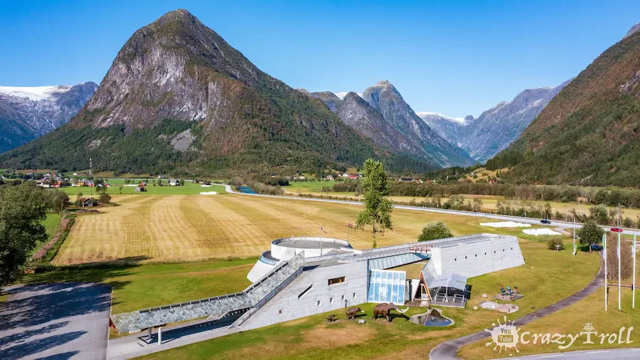
Traveling around the largest glacier in continental Europe, Jostedalsbreen, and visiting its gatherings, it will be interesting for you to look into the Norwegian Glacier Museum.
After all, it is here that you can get answers to the main questions. For example, why do glaciers have such a shape or color? And on a large panoramic screen, you will see a film shot in the most beautiful parts of the glacier.
Well, the exposition of time travel will not leave you indifferent and will make you think about climate change and what else can be corrected.
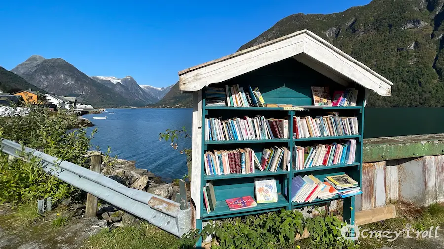
The small town of Fjærland is comfortably located on the shores of the Fjærlandsfjord, one of the branches of Norway’s largest fjord, the Sognefjord. And despite the fact that the population of the city is only about 300 inhabitants.
Fjærland is Norway’s main book town, with books everywhere in small shops, bus stops, and even telephone booths. Moreover, the total length of the bookshelves is longer than the main street.
All books are available to browse and buy. Fjærland was Scandinavia’s very first city of books, inaugurated in 1996.
And now, when you have already seen the different descents of the Jostedalsbreen glacier from a distance and learned more facts about glaciers in the museum.
We recommend that you visit the Nigardsbreen glacier, and this will definitely be your closest encounter with the glacier! After all, here you can even book a special tour and take a walk along the glacier itself. You can do it on this site: https://www.bfl.no/en/nigardsbreen-glacier-hikes/
And even if you decide not to take a tour, this is the same glacier that you can get very close to and have a good look at, since it does not hang over the valley, but lies in it and its visit is safe.
And you have two alternatives on how to do this. You can hike up to the glacier with a moderate climb in just over an hour. Or take a halfway boat ride on a glacial lake for 60 crowns. The boat runs from June 1 to September 25. More details can be found here: https://www.jostedal.com/en/the-glacier-boat/
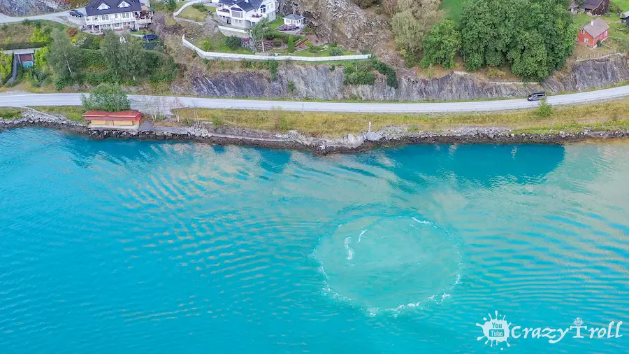
Having made a short stop in the town of Gaupne, you will see in reality what you saw on the model in the Glacier Museum. The site of glacial water discharge into the fjord after power generation.
It looks very unusual, and the water near the town of Gaupne is very blue due to the concentration of glacial silt.
The stop will not take long, but it will definitely impress you! After all, the movement of water is always fascinating, and when blue water breaks out from under the blue fjord, the impression can be safely multiplied by two!
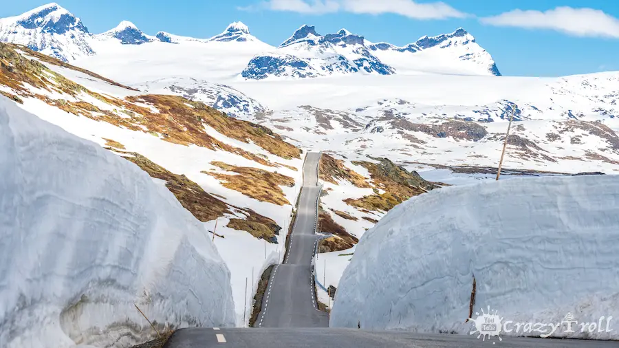
The picturesque Sognefjellet track is located on the territory of the Jotunheimen mountain range, which is often called the “Roof of Norway”. The road is 108 kilometers long and passes through the highest pass in Northern Europe.
The highest point of the road is 1434 meters above sea level. And get ready that you will often stop here, as there are many viewing platforms along the road from which you will admire the views of the valleys, mountains, and glaciers.
The road is closed for the winter, so it is not accessible all year round, but in the spring, immediately after opening, you will be able to catch high snowdrifts on its sides. We were there in the spring and in this video, we show what the road looks like in the spring.
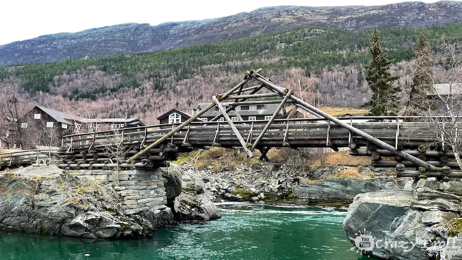
We recommend that you end this wonderful day in the already familiar city of Lom. We think this city is the best crossroads to beautiful places.
You can walk along the familiar streets and restaurants, and admire the river, and the ancient church. And also fill up your car before a trip to the Valdresfly plateau.
The Norwegian road Fv51 passes through the Valdresflye high plateau. This is the second highest mountain pass in Norway and the highest point of the road is 1389 meters above sea level, and the length of the road is 49 kilometers.
There are many stops with well-marked walking and hiking trails of varying difficulty. And on the highest part of the road, there is a cafe where Norwegians traditionally like to eat waffles with coffee, they say that waffles have a particularly strong and bright taste at the height.
And it’s definitely worth checking out! They also offer local food. The cafe is open while the road is open, every day from 10 to 17. In the summer, farmers bring large herds of reindeer to the plateau and this is probably the biggest chance in southern Norway to meet them.
Lake Bygdin is located on the Valdresfly plateau. And it is on it since 1912 that the highest mountain boat route in northern Europe has been running. Twice a day, the Bitihorn ship carries tourists along the route Bygdin – Eidsbugarden, a one-way trip that takes 1 hour and 45 minutes. The ship can accommodate 98 passengers.
Along the way, you can admire the 10 peaks of Jotunheimen National Park, over 2,000 meters above sea level. Also on the shores of the lake, there are two small ancient stone huts that deer hunters used as a refuge in the 19th century.
When traveling along Lake Byugdin, carefully look at the rivers flowing into it, they are all glacial and carry a lot of silt, which causes a beautiful mixing effect similar to watercolor paint.
The mountainous region of Venabygd is another gem that not all tourists get but is very popular among Norwegians. There are many dachas in this area, to which they go both in summer and in winter. After all, there is everything you need to relax!
The Venabygdfjellet area is popular for fishing, horseback riding, hiking, and cycling in summer and a skier’s paradise in winter. There are also many accommodation options here, from a hotel or campsite to cozy places with tables for stopping on motorhomes or with tents.
Here we recommend stopping for the night because the next day is better to start earlier, as we have planned a walk with you!
Waking up earlier and putting on comfortable shoes, we will go for a walk, as real Norwegians do. And here it depends only on your choice whether you will go through the entire circular route with a length of about 17 km or go along one of the trails recommended by us.
Most people park their cars in the car park next to the Venabu Fjellhotell here and the trails to the waterfalls at Myfallet and Dørafallet start. Walk a hundred meters north towards the lake. To the right of the road, you will see signs, this is the beginning of the trails.
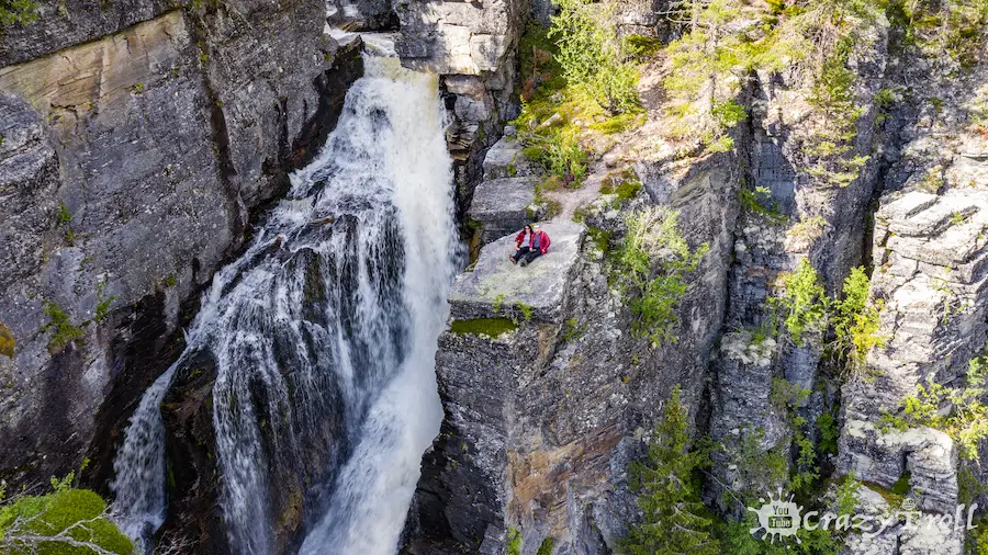
We recommend visiting the Myfallet waterfall. This is a picturesque four-cascade waterfall with a total fall height of 100 meters. It is located in the Norwegian wild forest, and going downstairs you can swim, but be prepared – the water will definitely be cool. Venabu Fjellhotell is 3.4 km from the waterfall. The road is flat, and the path is well marked, but at the end, there will be a rather steep descent to the river at the base of the waterfall.
Also on the Venabygd plateau, there is the Dørjuvet canyon, the Døra river flows along its bottom, and at the end of the canyon, the Dørafallet waterfall breaks down from the cliff with a roar. Its height is 80 meters. From Venabu Fjellhotell to the Dørafallet waterfall the path along the gorge is 7.5 km.
The trail is not difficult, but in some places, after the rain, the trail can be muddy. Always follow the signs with a red letter T, and look for signs at intersections, and you will definitely not get lost!
On the way to Oslo, we will stop to look at the tallest wooden building in the world – the Wooden Hotel in Brumunddal. Its height is 86 meters, and 72 hotel rooms are located on 18 floors.
Near the hotel, there is a wonderful recreation area and a park of 82,600 square meters – Mjøsparken. There are also sports grounds and beaches, and cafes. Great place to take a walk and stretch along the way!
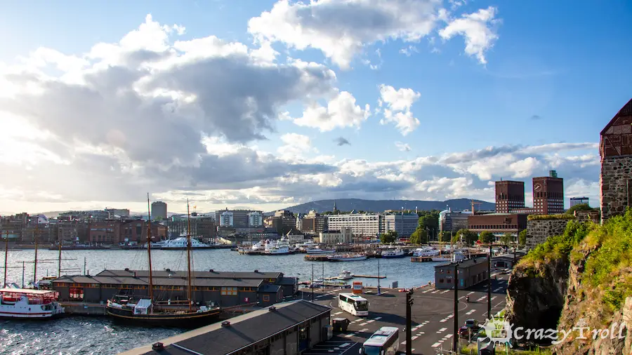
And of course, the city of Oslo – the capital of Norway deserves special attention! Here you can spend a week exploring museums and walking in parks and galleries. But we will try to meet in one day.
We will start our walk from the roof of the Oslo Opera House (GPS 59.907622727592575, 10.752869964636364), a great place to walk with a wonderful view of the city and the fjord.
And on the way back we will visit one of the newest quarters of Oslo, Tjuvholmen (GPS 59.90774857599629, 10.72164990080453). This is where the museum of modern art is located, so there are many interesting installations and architectural diversity on the streets of this area.
Here you can also have a bite to eat in one of the cafes, which are proud of their high standards and unusual presentation. And we will finish our walk around Oslo at Akershus Festning (GPS 59.90767082096687, 10.73679220087792).
After all, this is one of the most important and largest fortresses in Norwegian history and it was built at the end of the 13th century, as a medieval royal castle.
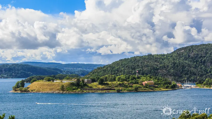
If you didn’t have enough time for Oslo, then we recommend spending the last day of your trip here, going to the Munch Museum, the Botanical Garden or going to the Holmenkollen ski jump. But if you are ready to continue the adventure, then on the 14th day we will go to the narrowest point of the Oslo fjord to the fortress on the island.
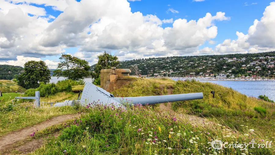
Oscarsborg Fortress is best known for the fact that on April 9, 1940, a torpedo was fired from it that sank the German cruiser Blücher. By the way, he still lies at the bottom of the Oslo fjord a little further than the fortress, this is described in detail in the museum.
Tools from different times are still preserved on the walls, and there are excellent walking trails around the fortress. You can walk to the very place where the torpedo was fired from. In general, the fortress will be interesting both for those who are interested in history and for those who just like to walk in beautiful places.
The younger brother of the aquarium in Ålesund is Drøbak Akvarium. It’s not big, but it’s the only aquarium in eastern Norway. The fauna of the Oslo Fjord is represented in 14 aquariums and two large water tanks. From deep sea eels to coastal crabs.
So if you are a lover of the underwater world, or did not have time to visit the Ålesund aquarium, then be sure to visit this place. Ticket price 100 kroons. More information here: https://drobakakvarium.no/priser.html
The distance from the city of Drøbak to the airport is 81 km but leave early, as traffic jams are possible on the highway from 14:30 to 18 on weekdays. We hope for your feedback about our route and what you managed to do during these 14 days and what you liked the most!
And also visit our YouTube channel, there are a lot of beautiful videos and useful tips related to traveling in Norway.